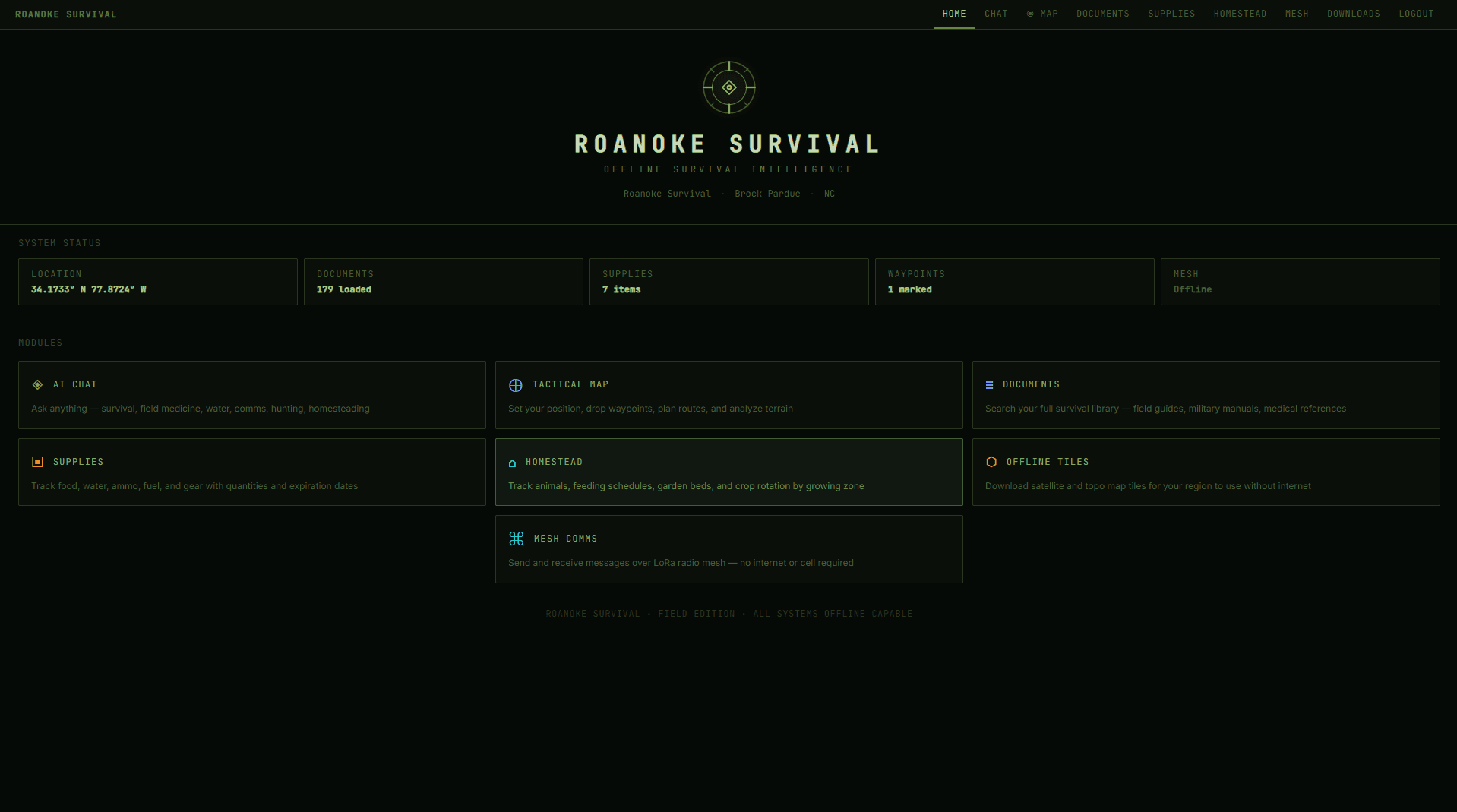
Off-grid intelligence
When the grid goes down,
Roanoke stays on.
A fully offline software suite for when infrastructure fails. Store your most critical knowledge — field manuals, medical references, survival guides — and query it with a local AI that works when the internet doesn't. Maps, mesh radio, supply tracking, and mission planning included. Runs on your own hardware. No internet required. Ever.
No spam. We'll reach out when it's ready to download.
What's inside
Everything you need. Nothing you don't.
Local AI Assistant
A powerful language model runs entirely on your machine. Ask questions, get plans, work through problems — no API keys, no cloud, no data leaving your hands.
Your Knowledge — Always Accessible
Load any PDF, manual, or document into your personal offline library. The AI reads and indexes everything, so you can ask questions and get answers from your own content — no internet, no search engine, no guessing.
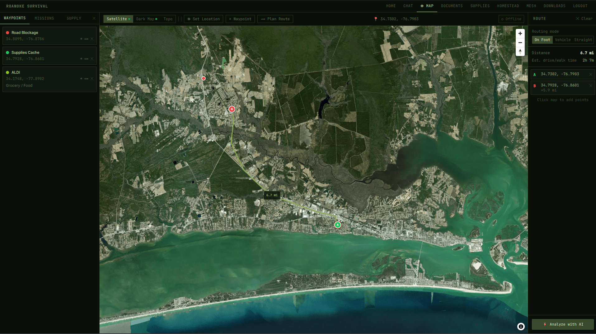
Offline Satellite Maps
High-res ESRI satellite imagery and topo maps downloaded for your entire state. Zoom in to street level with zero connectivity — and route with offline Valhalla.
Mesh Radio Network
Native Meshtastic integration lets you communicate with other nodes over LoRa radio — no cell towers, no internet, no infrastructure needed.
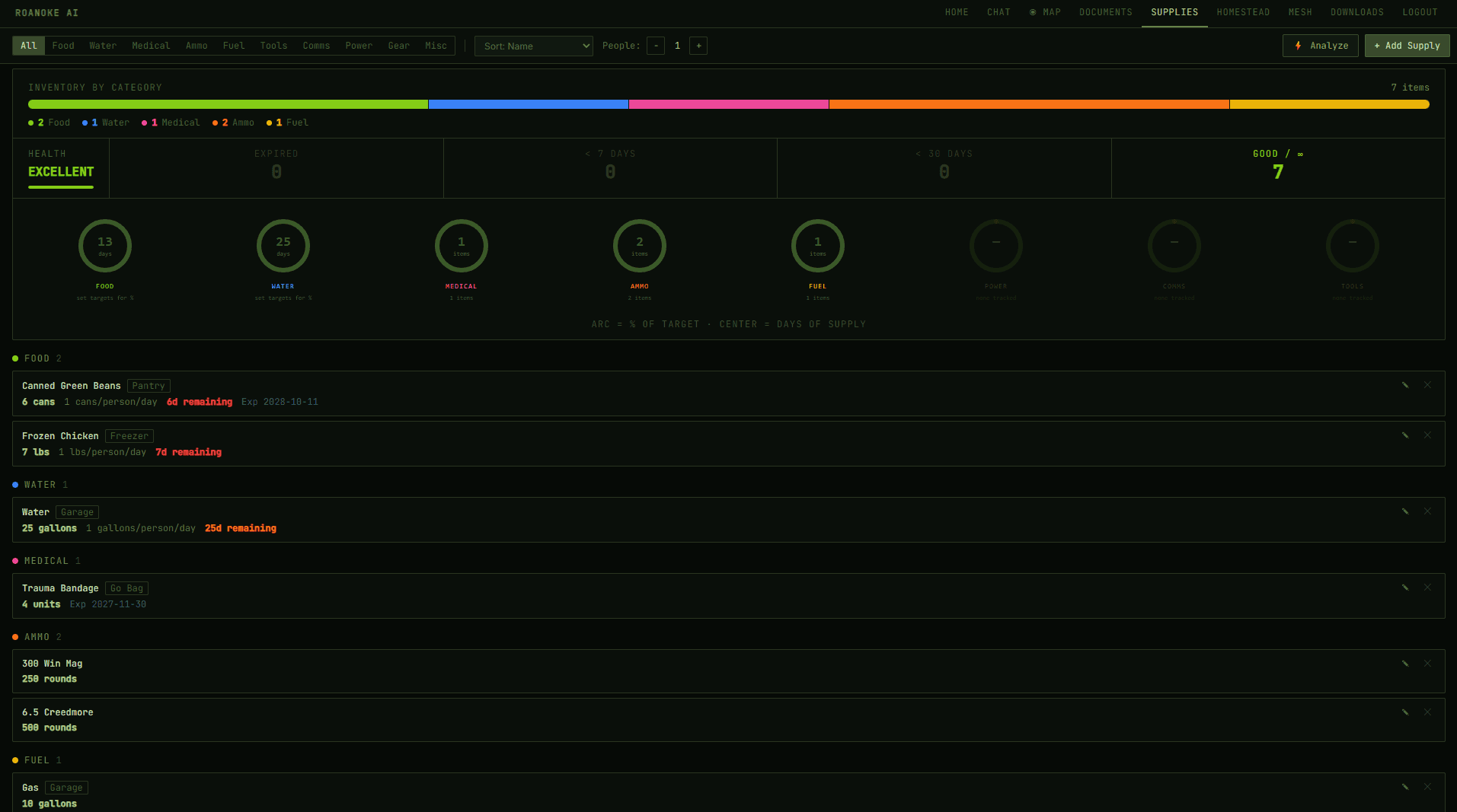
Supply Tracker
Track food, water, fuel, and medical supplies by days-of-supply. Know exactly what you have, what you're short on, and when to resupply.
Mission Planner
Place waypoints, plan routes, and coordinate with your group using offline map layers. Everything persists locally — no sync required.
Homestead Tracker
Manage livestock health schedules, crop rotations, planting dates by USDA zone, seed inventory, and daily checklists — all offline, all in one place.
Garden Planner
Zone-aware planting calendars calculated offline from your location. Know exactly when to start seeds, transplant, and expect harvest for dozens of crops.
No Cloud. Ever.
No subscriptions, no accounts, no telemetry, no license servers. Once it's on your machine it's yours. Pull the ethernet — it keeps working.
The feature that matters most
Your knowledge survives
with you.
When infrastructure collapses, the internet goes with it. Every article, tutorial, and reference guide you've ever relied on — gone. Search engines, YouTube, Wikipedia — all of it unreachable.
Roanoke Survival lets you build a personal offline library before that happens. Load in any PDFs — medical references, field manuals, homesteading guides, repair documentation, emergency protocols — and the local AI indexes all of it.
Then ask it anything. In plain language. Get answers drawn directly from your own documents, on your own machine, with no connection required.
Example queries from your library
“What's the treatment protocol for a deep laceration in the field?”
↳ sourced from wilderness-first-aid.pdf
“How do I purify water using a slow sand filter?”
↳ sourced from emergency-water-guide.pdf
“What are the signs of sepsis and how do I respond?”
↳ sourced from military-medical-handbook.pdf
“How do I can tomatoes using a pressure canner?”
↳ sourced from homestead-preservation.pdf
“What's the torque spec for my generator's carburetor?”
↳ sourced from honda-eu7000is-manual.pdf
How it works
Download once. Works forever.
Download and install
Run the installer on Windows or Linux. It sets up the app, AI engine, and tile server automatically. One script, no technical knowledge required.
Set your home location and download maps
Pick your state and a focus area around your home. The app pulls high-res satellite and topo tiles onto your drive. Takes a few minutes — runs once.
Works grid or no grid
Everything runs locally. No subscriptions, no cloud, no single point of failure. Pull the ethernet, turn off Wi-Fi — it keeps working.
Interface preview
Built for field use.
Dark, low-power UI designed for rugged screens. Every panel works offline.
Dashboard
Offline Satellite Map — Newport, NC
Supply Tracker
AI Chat
1. Biological — coliform bacteria, giardia, cryptosporidium. Treat with boiling (1 min) or iodine tabs.
2. Chemical — heavy metals (near industrial sites), nitrates (agricultural runoff), fuel contamination.
3. Physical — turbidity, color, odor. Murky water needs filtration before chemical treatment...
Mesh Radio
Offline Maps (preview)
Why we built this
The original Roanoke didn't make it.
In 1587, 115 English settlers landed on Roanoke Island off the coast of what is now North Carolina. They were cut off from resupply. They had no way to communicate across distance, no reliable way to navigate unfamiliar terrain, and no shared system for managing what they had. When a supply ship finally returned three years later, every one of them was gone. No bodies. No explanation. Just the word CROATOAN carved into a post.
They didn't fail because they weren't tough enough. They failed because they were isolated and uninformed — without the tools to coordinate, plan, and survive when the infrastructure they depended on disappeared.
That's exactly the problem Roanoke Survival is built to solve.
If those colonists had a local AI they could ask questions, offline maps of the surrounding territory, a way to communicate with other groups without relying on outside infrastructure, and a system for tracking their food and supplies — the story might have ended very differently.
We built this for the people who think about that. The ones who don't assume the grid will always be there. The name is a reminder of what's at stake when it isn't.
Want to see it live?
We'll walk you through the full setup — AI chat, offline maps, mesh radio, and the homestead tools — on a real machine with no internet connection.
Hardware option
Want it pre-installed on a rugged laptop?
We may offer a pre-configured hardware option — Roanoke Survival fully installed, maps pre-loaded for your state, ready to go out of the box. No setup required. Drop your email if that's something you'd want.
No commitment. Just helping us understand demand.
FAQ
Common questions.
What hardware do I need?
Any Windows or Linux machine with a modern CPU and at least 16 GB RAM will run it well. An SSD with 50–200 GB free is recommended depending on how many states you download. The AI model runs on CPU — no GPU required.
Does it ever connect to the internet?
Only when you choose to download maps or updates. Once your maps are downloaded, the app runs fully offline. No analytics, no telemetry, no cloud sync, no license checks.
What maps are included?
ESRI World Imagery (Maxar satellite) and a dark street basemap. You select which states to download at zoom levels 0–14, plus a high-detail focus area (zoom 15–17) around your home. You can add more states any time.
What AI model does it use?
Roanoke Survival uses Ollama to run a local LLM on your machine. The model is configurable — it ships with a solid default that balances speed and capability on mid-range hardware.
Can I add my own documents?
Yes. Drop PDFs into the ingest folder and the app indexes them into a local vector database. The AI will answer questions from your content without sending anything off your machine.
When is it available?
We're finishing up and gauging interest now. Join the waitlist and you'll be first to know when the download is ready.
Get early access
Be first in line when it drops.
We're building Roanoke Survival for people who take preparedness seriously. Join the waitlist and we'll reach out when the download is ready.
No spam. No obligations. Just a heads up when it's ready.